arcgis-api-for-javascript-vue
vue + ArcGIS 地图应用系列二:加载地图

1. 创建 Vue 项目
我们利用 Vue-CLI 工具进行快捷创建
- 下载 Vue-CLI 工具
yarn add global @vue/cli # or: npm i @vue/cli -g
- 创建 Vue 项目
根据自己项目需求进行配置,这里不过多的赘述。
vue create example # example为项目名称,我这里以example为例
- 进行项目并启动测试
cd example
yarn serve
访问 http://localhost:8080 ,出现 vue 界面说明项目创建成功。
2. 引入 ArcGIS API
因为历史原因,ArcGIS API 使用的 AMD 模块化思想,与 Vue 的模块化思想相冲突。ArcGIS 官方给出了
esri-loader解决方案,我们使用这个包进行 ArcGIS API 的异步加载
- 下载 esri-loader
yarn add esri-loader # or: npm i esri-loader -s
- 配置 ArcGIS API 异步加载地址
我们在第一讲中讲到的 ArcGIS API for JavaScript 本地部署(开发环境) 就派上了用场。
- 新建一个配置文件 src/map/config.js 配置托管的 API 地址
export default {
  // load配置
  loadConfig: {
    url: "http://localhost:3000/arcgis-3.32/init.js", //托管 API 地址
  },

  // 初始化位置
  startExtent: [
    118.54805985687483,
    36.48416358185947,
    120.25643388031263,
    35.52697974396869,
  ],
};
- 在 src/map/init.js 中新建 ArcGIS 加载类
代码如下
/* eslint-disable no-unused-vars */
/*
 * @Author       : 震雨 LuckRain7
 * @Date         : 2020-08-20 10:44:38
 * @LastEditTime : 2020-12-15 10:45:35
 * @Description  : arcgis地图部分
 * @ Love and Peace
 */

import { loadModules, loadCss } from "esri-loader"; // 异步加载模
import config from "./config"; // 配置项

function ArcGIS() {
  this.map = null; // 地图
  this.baseMap = null; // 地图底图
}

ArcGIS.prototype.init = function init($el) {
  // 加载地图必备样式文件
  loadCss("http://localhost:3000/arcgis-3.32/esri/css/esri.css");
  loadCss("http://localhost:3000/arcgis-3.32/dijit/themes/claro/claro.css");

  // 异步加载对应 js 模块
  loadModules(
    [
      "esri/map",
      "tdlib/SDTDTLayer",
      "tdlib/SDRasterLayer",
      "tdlib/SDRSAnnoLayer",
      "esri/geometry/Extent",
      "esri/SpatialReference",
      "dojo/parser",
    ],
    config.loadConfig
  )
    .then(
      ([
        Map, // 地图模块
        SDTDTLayer, // 山东天地图矢量地图
        SDRasterLayer, // 山东天地图影像地图
        SDRSAnnoLayer, // 山东天地图影像地图注记
        Extent, // 范围模块
        SpatialReference, // 坐标系模块
        Parser, // 样式解析模块
      ]) => {
        // 设置地图地图图层
        this.baseMap = {
          vectorMap: new SDTDTLayer(), //矢量地图
          rasterMap: new SDRasterLayer(), //影像地图
          rasterMapAnnotation: new SDRSAnnoLayer(), //影像注记
          type: 1, // 1 为矢量 | 2:影像
        };

        Parser.parse(); // 解析

        // 设置初始化地图位置
        const startExtent = new Extent(
          ...config.startExtent,
          new SpatialReference({ wkid: 4490 })
        );

        // 添加地图实例
        this.map = new Map("map", {
          extent: startExtent, // 初始化位置
          zoom: 10, // 缩放级别
          logo: false, // esri logo
          maxZoom: 18, // 最大缩放级别
          sliderPosition: "bottom-right", // 缩小放大按钮位置
        });

        // 将图层添加到地图实例上 (图层,图层层级)
        this.map.addLayer(this.baseMap.vectorMap, 0);
      }
    ) //end
    .catch((err) => {
      console.error(err);
    });
};

export default ArcGIS;
3. 创建地图组件并加载地图
- 引入我们上面创建好的模块,并进行实例化
import ArcGIS from "@/map/init.js";
const Map = new ArcGIS();
- 执行其中的 init 方法。并传入对应 dom 的 ID
<template>
  <div id="app">
    <Header />
    <div class="main">
      <div id="map"></div>
    </div>
  </div>
</template>

<script>
import Header from "@/components/Header.vue"; // 引入头部组件
import ArcGIS from "@/map/init.js";
const Map = new ArcGIS();

export default {
  name: "App",

  components: {
    Header,
  },

  mounted() {
    Map.init("map");
  },
};
</script>

<style lang="less">
html,
body {
  margin: 0;
  padding: 0;
  width: 100%;
  height: 100%;
}

.main {
  position: absolute;
  top: 70px;
  bottom: 0;
  width: 100%;

  #map {
    width: 100%;
    height: 100%;
  }
}
</style>
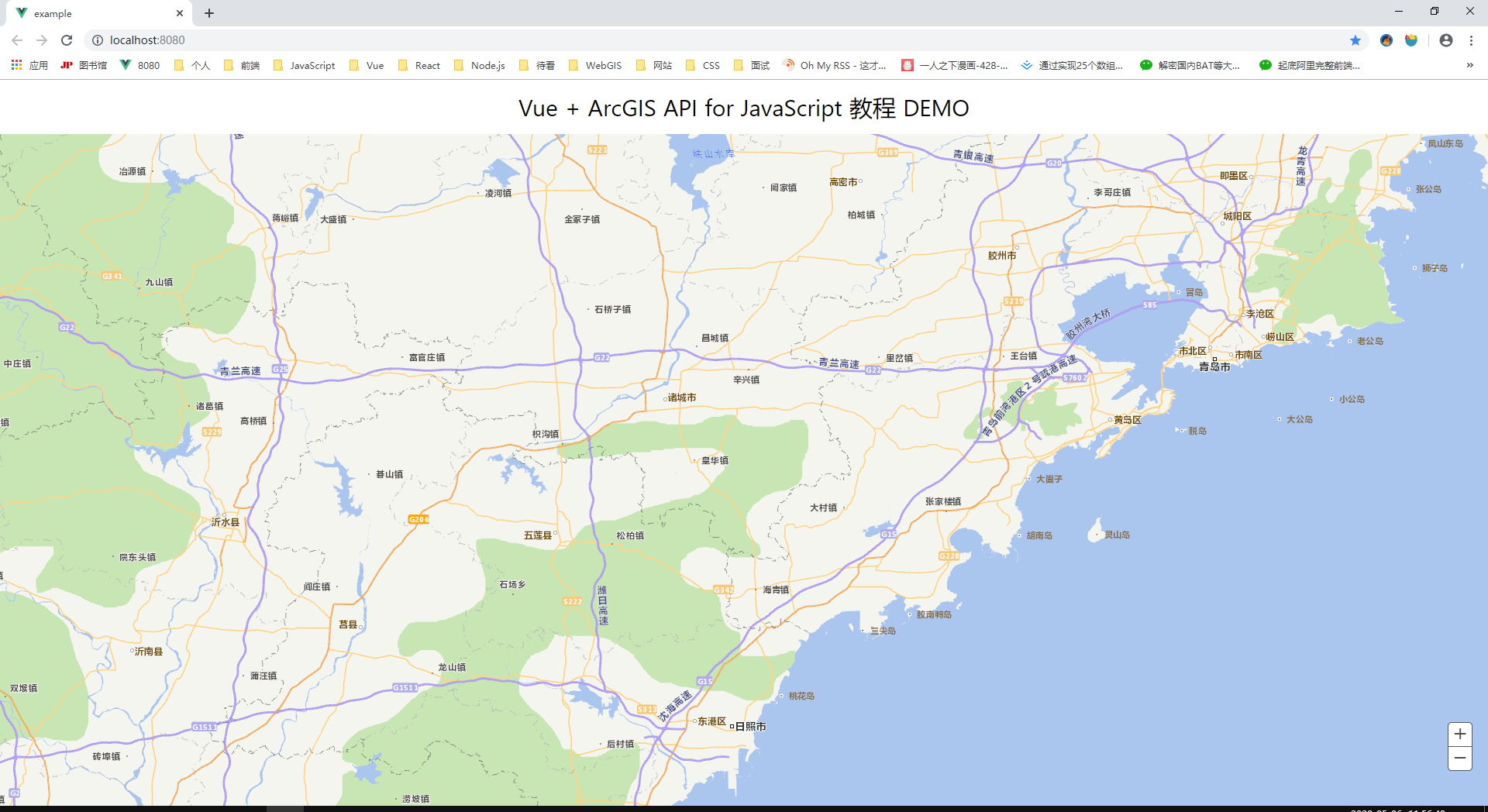
4. 效果图